RAEGE is the spanish/portuguese acronym for “Atlantic Network of Geodynamic and Space Stations” (“Red Atlántica de Estaciones Geodinámicas y Espaciales” in Spanish, and “Rede Atlântica de Estações Geodinâmicas e Espaciais” in Portuguese).
RAEGE project arises in 2010 with a Memorandum of Understanding between the Regional Government of the Azores and the Government of Spain (Spanish National Geographic Institute – IGN Spain) to set up a network of Space Geodetic Stations to meet the international requirements needed for the Global Geodetic Observing System (GGOS).
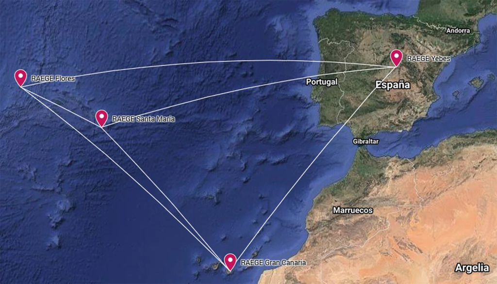
The project aspires at constructing, installing, and operating four fundamental geodetic stations:
- Two in Spain (Yebes and Gran Canaria)
- Two in the Azores (Santa Maria and Flores)
The RAEGE Sites are located on three different tectonic plates: Yebes (Spain) in the Eurasian plate, Flores (Azores) in the North American plate, Gran Canaria (Canary Islands) in the Nubian plate and Santa Maria (Azores) in the Azores Triple Junction Region. Due to the network geometry and the sites’ location, the focus of study is centered in the North Atlantic region, allowing for instance a close monitoring and assessment of the geodynamics of these tectonic plates.
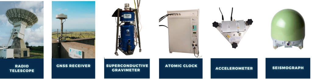
Each RAEGE Site is equipped with at least one VGOS radio telescope (VLBI Global Observing System), one permanent GNSS station (Global Navigation Satellite System), one superconductive gravimeter, one atomic clock (hydrogren maser), and a seismograph/accelerograph. Yebes Observatory also has a Satellite Laser Ranging (SLR) facility.
All these instruments provide the geodetic infrastructure necessary for monitoring the Earth’s system and global change research, allowing to quantify the changes in space and time of our planet. Observations will allow us to map and monitor changes in the Earth’s shape, rotation, and mass distribution, providing the global geodetic reference frame for measuring and interpreting global change processes as climate change, sea level estimations, among others.
RAEGE contributes to the Global Geodetic Observing System (GGOS) of the International Association of Geodesy (IAG), which defines the requirements needed to set up a global geodetic infrastructure. The main purpose of GGOS is the upgrade, expansion, and maintenance of a global network of Geodetic Core Sites that provide observations that will allow a better understanding of the dynamics of the Earth’s environment and conditions of global change to make decisions of long-range societal benefit.
The strategic objectives for RAEGE are:
- The full integration of RAEGE radio telescopes in the VGOS network.
Fig.3: GGOS Core Sites
[Ref.] GGOS.org - The constitution of four GGOS core stations
- The strengthening, integration, and increase of activities in partnership with other scientific entities such as universities, science centers, collaborative laboratories, and/or science networks.
- The mobilization of research institutions comprising elements belonging to the Scientific and Technical Advisory Committee (STAC) of RAEGE for the development of scientific projects and dissemination of the work developed on the RAEGE sites.
- Participation in national and international meetings and congresses to increase the visibility of RAEGE on a global scale.