
Since 2021, several lines of investigation were defined. Different scientific projects and research were initiated. The analysis group focused on the following projects during these years:
– Use of different data analysis software to compare results and test software features. The software used were the following:
- VieVS (Research Unit Higher Geodesy of the GEO Department at TU Wien)
- Where (Norwegian Mapping and Cadastre Authority)
- nuSolve (GSFC VLBI Analysis Center’s software)
– Special focus on VGOS data processing. The main objectives of processing these sessions were:
- Analysis of processing differences between VGOS sessions and R1/R4 sessions;
- Optimization of the processing strategy;
- Testing the capacity of the VGOS data;
- Analyze geodetic observations from RAEGE stations.
– Comparison of VLBI and GNSS products at co-located sites and multi-technique analysis.
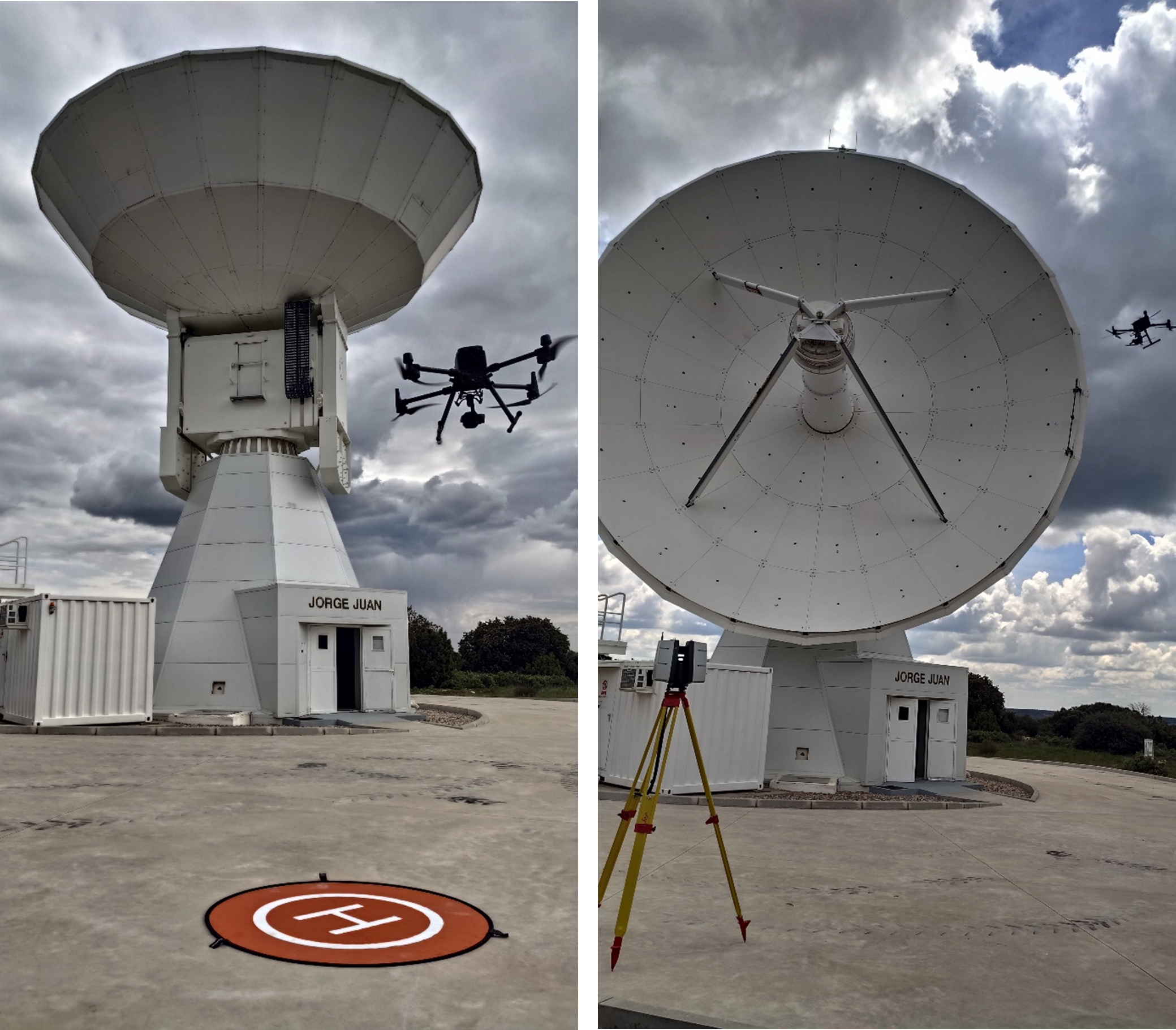
– Study of the gravitational deformation of antennas:
- Ongoing project, in partnership with the Politechnic University of Valencia, to study the gravitational deformation of antennas and comparison of different measurement techniques using terrestrial laser and UAV photogrammetry (Fig.1)
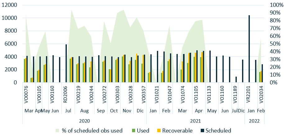
– Performance evaluation and statistics of RAEGE stations:
- Equipment testing and improvements, namely identification of clock errors.
- Analysis of the quality of data obtained by each of the techniques present at the stations, namely GNSS and with a special focus on VLBI data.
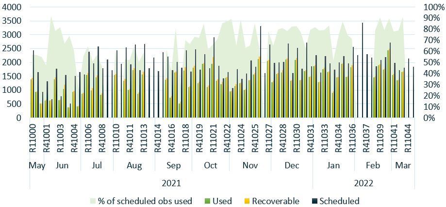
– Special focus on Intensives observations. The main objectives of processing these sessions are:
- Optimization of the processing strategy;
- Empowering both the RAEGE Analysis Group and the RAEGE stations to undertake end-to-end data .
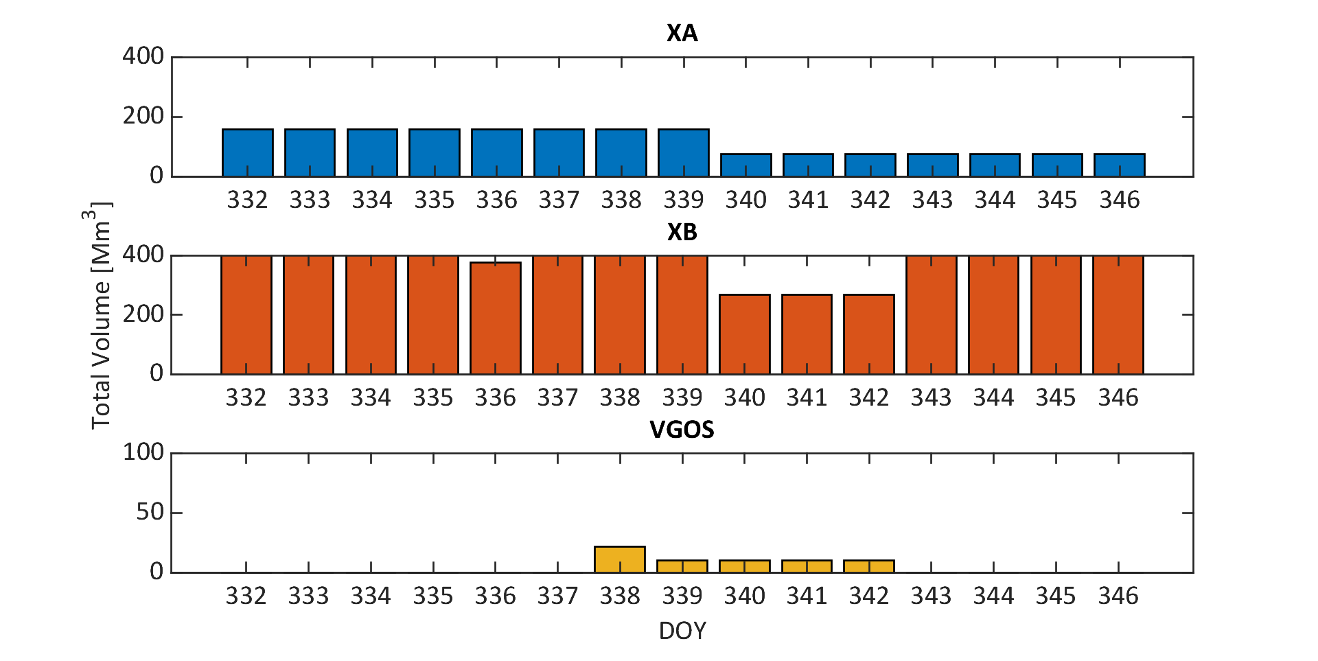
- Initiate a comprehensive study assessing the impact of RFI on the quality of UT1 data.
– Evaluation and focus on the computation and processing of all the historical data of VLBI, 1984-2022, and the impact of using different mathematical parameters and different TRFs.
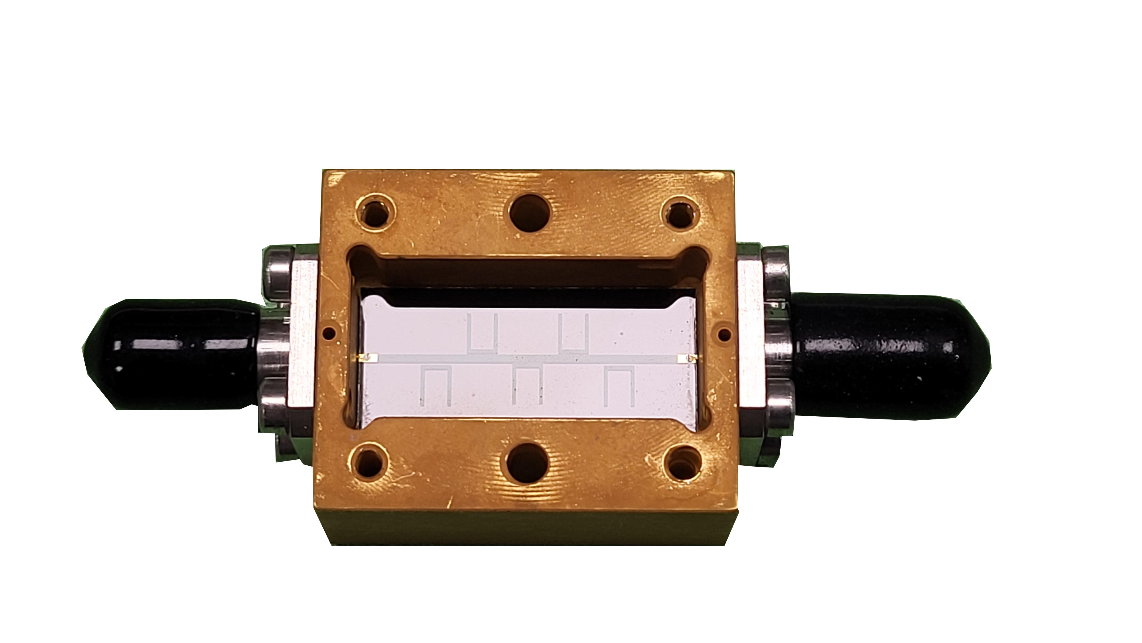
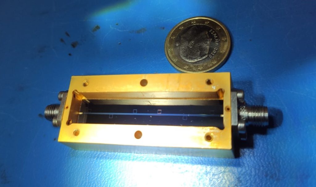
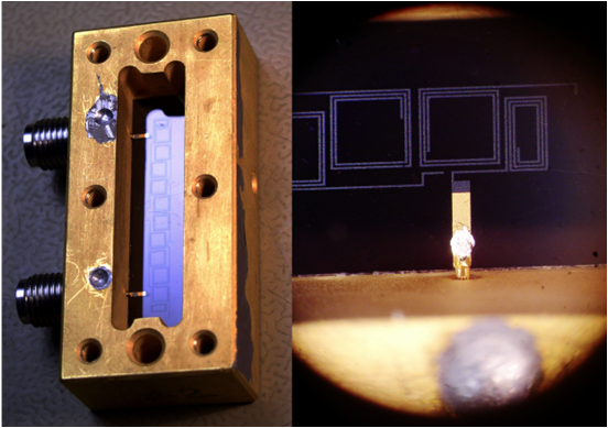
- Developments for VLBI/VGOS cryogenic receivers.
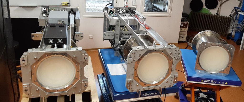
- Development of high-temperature superconducting (HTS) filters to reject radio interferences.
- “Consistency of VLBI estimates in the CONT17 campaign” (Puente et al.), EVGA Meeting 2021
As part of its observing program, the International VLBI Service for Geodesy and Astrometry (IVS) arranges special observation campaigns of continuous Very Long Baseline Interferometry (VLBI) known as CONT campaigns. The last CONT campaign (CONT17) was carried out by the end of 2017 and consisted of three networks observing in parallel: two legacy S/X networks and a VGOS broadband network. This strategy brings an interesting opportunity for the comparison of VLBI estimates as result of the processing of the data acquired the antennas of each network.
The purpose of this contribution is to compare the consistency between the estimates of the different networks in order to gain insight into the influence of the geometry of the network and the observing technology on the geodetic products estimated through VLBI.
- “Analysis of VGOS sessions: Evaluation of performance with different software” (Azcue et al.), IVS General Meeting 2022
VGOS (VLBI Global Observation System) is a new generation VLBI system. It has been developed since 2005 and it is based on the so-called broadband delay that uses four or more frequency bands. High data rate observations are taken by fast-slewing antennas, smaller than those used in the current legacy S/X infraestructure. These improvements in instrumentation are aimed at obtaining geodetic products more accurate.
In order to test the analysis of these new data, the historical VGOS sessions have been analyzed with different software. Difficulties in the current processing and similarities with the S/X generation processing are studied. Results in terms of the accuracy in EOP (Earth Orientation Parameters) estimation and coordinates repeatability are also discussed in this contribution.
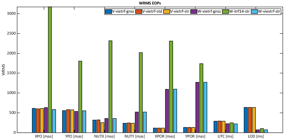
- “VLBI-Based Assessment Of The Consistency Of The Conventional EOP Series And The Terrestrial Reference Frames” (Moreira et al.), Reference Frames for Applications in Geosciences (REFAG) 2022 (October 2022) | 10ª Assembleia Hispano-Portuguesa de Geodesia e Geofísica (AHPGG) (November 2022)
The Global Geodetic Observing System (GGOS) of the International Association of Geodesy (IAG) envisages stringent accuracy goals for the International Terrestrial Reference Frame (ITRF) realization in terms of position (1 mm) and velocity (0.1 mm/year). These requirements entail that the Earth Orientation Parameters (EOP) should be estimated with similar accuracy.
The ITRF is based on the combination of solutions from the four space geodetic techniques, with each new release incorporating updated data and models. Likewise, the current conventional EOP series, IERS 14 C04, is produced in a separate process following a different strategy, based on a monthly combination of the EOP estimates obtained by the analysis centers of each space geodetic technique. Using independent processes might cause slow degradation of the consistency among EOP and the reference frames or a misalignment of the current conventional EOP series. The recent release of the ITRF2020 brings an exciting opportunity to investigate this topic.
In this work, we empirically assess the consistency among the conventional terrestrial reference frames and EOP through the analysis of Very Long Baseline Interferometry (VLBI) data, taking different terrestrial frames as alternative settings in the analysis. ITRF2020, ITRF2014, and the terrestrial frame used to produce the ICRF3 are considered in this work. This study allows evaluating if the selection of the terrestrial frame has a significant impact on the consistency of the estimated EOP and assesses its agreement with the conventional EOP series.
An extension of this work was presented on the European VLBI General Assembly 2023.
- “Alicante IVS Analysis Center” (Karbon et al.), European Geosciences Union (EGU) 2023
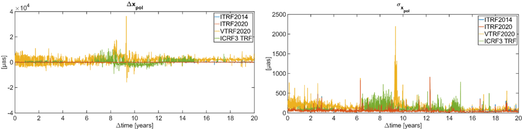
Very Long Baseline Interferometry (VLBI) is a highly accurate method, used since the 1970s in astrophysics as well as in geodesy. It contributes significantly to the global international terrestrial reference frame (ITRF) and is the only space geodetic technique able to realize the international celestial reference frame (ICRF) as well as to observe the full set of Earth orientation parameters (EOP: polar motion, universal time, precession / nutation). The IVS (International VLBI Service for Geodesy and Astrometry) analysis center in Alicante UAVAC (University of Alicante VLBI) was established as an associate AC in 2018 at the department of Applied Mathematics at the University of Alicante, within the research group of space geodesy and space dynamics. Further, we have a close partnership with the IGN (Instituto Geográfico Nacional) and RAEGE (Red Atlántica de Estaciones Geodinámicas y Espaciales / Rede Atlântica de Estações Geodinâmicas e Espaciais). In the first quarter of 2022 we started with the first steps to become an operational AC, with the final goal to be a full contributor to future ICRF and ITRF realizations, as well as operational products like the IVS combined EOP products. In this report we introduce the community to our group, our technical setups in terms of hard- and soft-ware, as well as our preliminary products. We present the first results based on our reanalysis of the IVS-archives (1979-12.2022) using VieVS 3.2 (one of several software we plan on using), and show the main geodetic products, i.e. EOP, CRF and TRF.
- “RAEGE Capabilities: A Simulation Study” (Azcue et al.), European VLBI General Assembly 2023
RAEGE is a project resulting from the cooperation between the National Geographic Institute of Spain (IGN Spain) and the Government of Azores. It is aimed to set up four multi-technique stations: two in Spain (Yebes and Gran Canaria) and two in Azores (Flores and Santa Maria). These stations will stablish a Iberatlantic Very Long Baseline Interferometry (VLBI) observing network meeting the international requirements needed for VGOS. Currently the VGOS-antennas at Yebes and Santa Maria are operational, the other two are in the planning stage. The RAEGE project focuses not only on the instrumentation and on operating the observations and stations, but also on developing analysis capabilities. With this objective a cooperation between IGN Spain, Azores Government and the University of Alicante was born for exploding the geodetic observations of the RAEGE observatories for geodetic and geodynamic purposes. The key feature of this network is its distribution over three tectonic plates (Eurasian, African and North American), which will augment the estimates of the movements between the plates, both in direction and speed and thus improve the TRF (Terrestrial Reference Frame). Major improvements are expected for constraining the rotational component of the African plate, where we have currently only one VLBI station in South Africa and a very sparse network of about 30 IGS-GNSS antennas over the entire continent. Within this study we want to explore the capabilities of the RAEGE-network in ”stand-alone” mode, i.e. wich accuracies can be reached with this network in terms of EOP and station position accuracies, and in a second step we evaluate the performance when expanding the network with additional VGOS-antennas of the IVS network.
An extension of this work was presented as a poster on IUGG General Assembly 2023.